.svg)

A vision for Water: SkyTEM’s Pivotal Role in the FRESHEM-NL Project
SkyTEM’s Knowledge Hub brings together research, project cases, and insights from our global work. Here you can explore peer-reviewed publications, technical papers, and field experiences that reflect our ongoing commitment to scientific integrity and innovation in airborne geophysics.
A Collaborative Vision for a Sustainable Future
At SkyTEM, we are deeply committed to providing the essential data needed for sustainable water management. That’s why we are proud to be a key partner in the groundbreaking FRESHEM-NL project, a large-scale collaboration aimed at mapping the Netherlands’ vital fresh groundwater reserves.
We have been contracted by a consortium of Dutch provinces, water boards, drinking water companies, and research institutes Deltares and TNO-Geological Survey of the Netherlands, all working together to secure a sustainable future for the country’s water resources. Speaking on the significance of this project, Jan Gunnink from TNO Geological Survey of the Netherlands notes that:
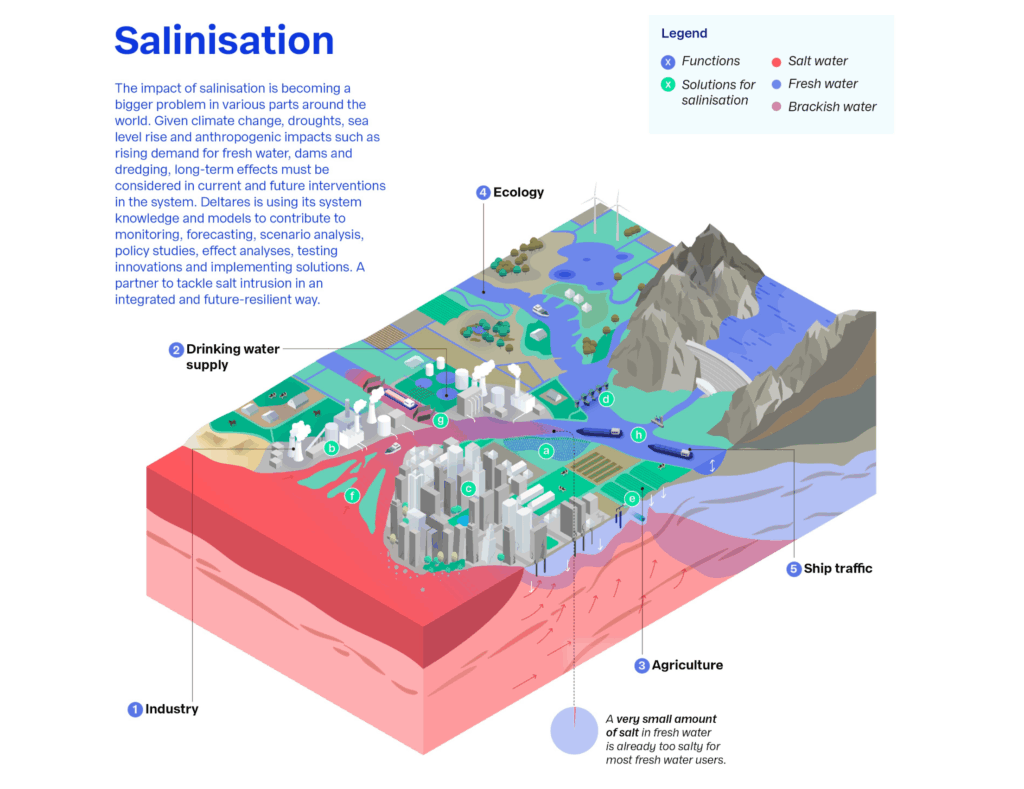
“Climate change is altering the availability of fresh water, while we are using more and more fresh water. Because of the location by the sea, some of the groundwater in the Netherlands is saline. Over time, rising sea levels lead to salinization of groundwater in coastal areas, and saline groundwater is also flowing upwards under deep polders. This salinization is damaging for agriculture and nature. It is therefore important to map the salinity of groundwater.“
Geert-Jan Nijsten from Deltares adds:
“It is also important to understand the location of clay layers. Clay layers protect groundwater underneath those layers against contamination from above. Knowledge about clay layers is also necessary to better understand groundwater flow and, with that, the possible consequences of groundwater use, changes in water management and climate change. To ensure that nature and agriculture suffer as little as possible from salinization and that sufficient drinking water is available, it is important to have a clear picture of the subsoil and groundwater. With the wealth of information the FRESHEM project is generating, we are making an important contribution to sustainable water management for the future.”
Our Role: Cutting-Edge Technology in Action
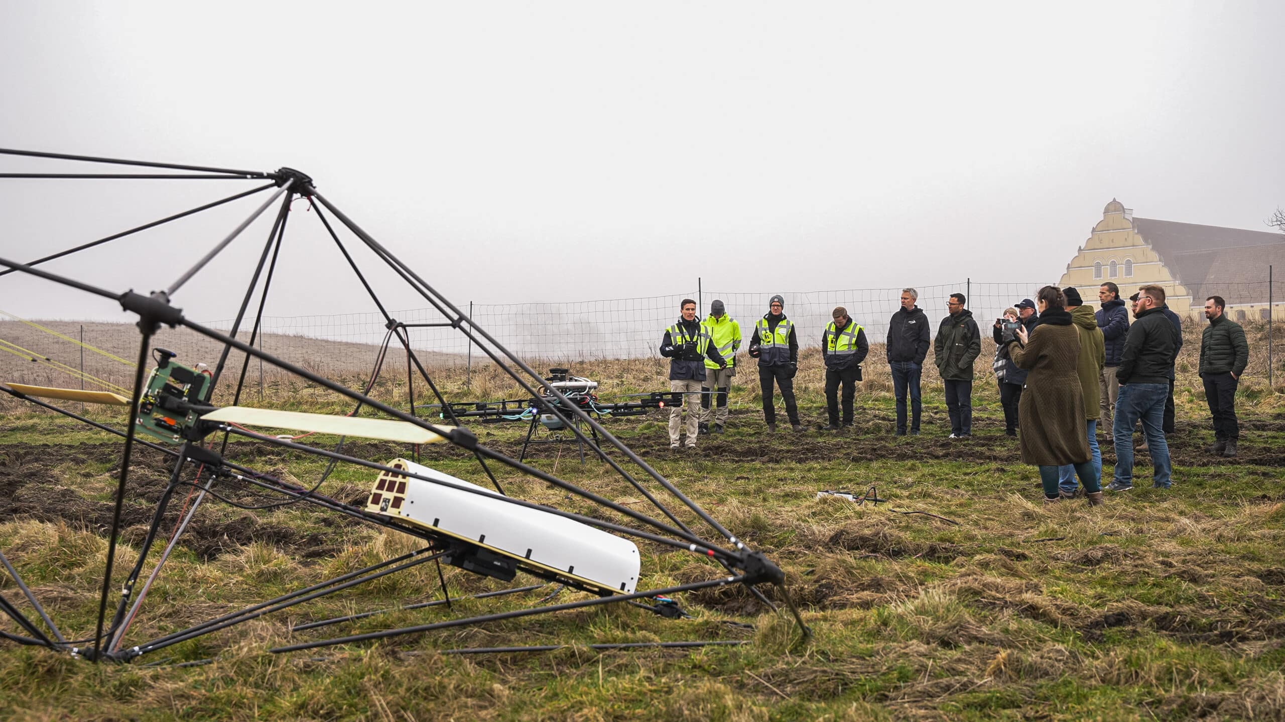
Our part in this monumental project involves deploying our advanced helicopter-borne geophysical system. Our specialized team is conducting extensive electromagnetic surveys across seven Dutch provinces. The project’s fieldwork phase was carried out from August until the middle of November 2025, during which two of our helicopters covered over 25,000 line kilometers. The flight plan includes surveying key areas in the provinces of Groningen, Drenthe, Friesland, North and South Holland, Zeeland and North Brabant. Flying at an altitude of approximately 80 meters, our helicopter-mounted transmitter loop induces currents into the Earth, allowing us to map the subsurface with unparalleled detail. This cutting-edge TEM technology allows us to precisely identify the location of fresh, brackish, and saline groundwater, as well as the thickness and position of crucial protective clay layers, all down to a depth more than 200 meters.
The Four-Step FRESHEM-NL Process
The FRESHEM-NL project is structured into four key phases to ensure a comprehensive and innovative approach. Fieldwork involves taking measurements and collecting soil samples for laboratory analysis. The helicopter measurements are the core of our contribution, collecting data with our specialized loop-shaped transmitter and receiver. The data from these flights are then used to create a 3D model of the subsurface, linking the signals to specific locations and processing them into a detailed map of the soil’s electrical resistance. The final phase, innovation, focuses on further developing these techniques and researching new ones to improve the accuracy and detail of the 3D models.
Empowering Sustainable Decision-Making
This is more than just a survey; it’s a foundation for intelligent, sustainable decision-making when it comes to water management addressing water scarcity and environmental impact. The high-resolution data we collect enables Deltares and TNO to construct a comprehensive 3D model of the subsurface, enabling project partners to make informed choices about water use and conservation. The project results are expected to be available by mid-2027. As SkyTEM’s CEO Morten Melbye states,
“Groundwater mapping is at the core of SkyTEM’s DNA. The protection of groundwater resources on a national scale requires wide-scale collaboration, and the FRESHEM-NL project is a perfect example of this. We are proud to deliver the essential data that empowers our partners to make sustainable decisions, ensuring the long-term health of these vital resources for generations to come.”
SkyTEM for Groundwater Mapping
Discuss your project with a SkyTEM specialist.
We’ll help scope the right airborne electromagnetic survey for your goals and terrain.